Last year I visited many breathtaking places across the U.S. In Florida, in January and again in March after a February Malaysia/Borneo odyssey, from the Keys to Kissimmee Prairie. On to Texas in April, from Sea Rim State Park on the Gulf, clinging to the Mexican border west to Laredo's urban Lake Casa Blanca International State Park, on to wondrous Big Bend National Park and then Seminole Canyon Historical Site. Then April saw me jumping back and forth between New Mexico to Arizona, camped at places like Picacho Peak State Park between Tucson and Phoenix, visiting the Superstition Mountains and the Sky Island complexes of the Santa Catalina and Santa Rita Mountains.
Last weekend, while I was in Paradise banding hummingbirds, the annual Elegant Trogon count took place here in the Chiricahuas. As arriving birders associated with the Tucson Audobon Society arrived, I was struck by the newcomers who had never visited the Chiris before and their love-at-first-sight enthusiasm for Cave Creek Canyon. Their home was Madera Canyon, another American nesting spot of the Mexican bird. Situated in the Santa Ritas south of Tucson, about halfway between that population center and the Mexican border, Madera Canyon is incredible. I visited it first with my arachnologist friend Brent and his students, and then again after they moved on toward California. I look forward to my next visit. But it is a short drive from the Sonoran desert sprawl of America's thirty-third largest city, whose greater metropolitan area is home to more than one million people. It ain't exactly a "well kept secret" as I have heard remarked about Cave Creek Canyon.
Even closer to Tucson city limits, the Santa Catalinas draw daily visitors from Phoenix as well. The Catalina Highway that rises to above 9000 feet near Mt. Lemmon is thirty miles of perfectly paved access to high elevation heat relief. I look forward to my next visit to this Sky Island as well, and have fond memories of a hot and dry day in Tucson becoming an evening flipping snow-covered rocks in successful search of scorpions.
The Trogon count participants that spend a great deal of time in Madera Canyon marveled at the Chiricahuas just as I did when I visited last year for a week that turned into four months. I still marvel every day, and each day I work at the VIC someone remarks on the uniqueness and splendor of Arizona's largest Sky Island. Far off the beaten path, the Chiri charm and cheer takes a little more work to experience.
Some Arizonans who venture toward the Chiris simply visit the Chiricahua National Monument on the west side of the range after leaving the interstate at Willcox. Fort Bowie National Historic Site lies in the valley below and a full day's outing can be had visiting both. Only the few cross Onion Saddle to descend toward Cave Creek Canyon and Portal. Others make Cave Creek Canyon their destination, most staying on the interstate into New Mexico and dropping south on Highway 80 five miles into the state and proceeding thirty miles to Rodeo, NM before heading back west into Arizona to Portal.
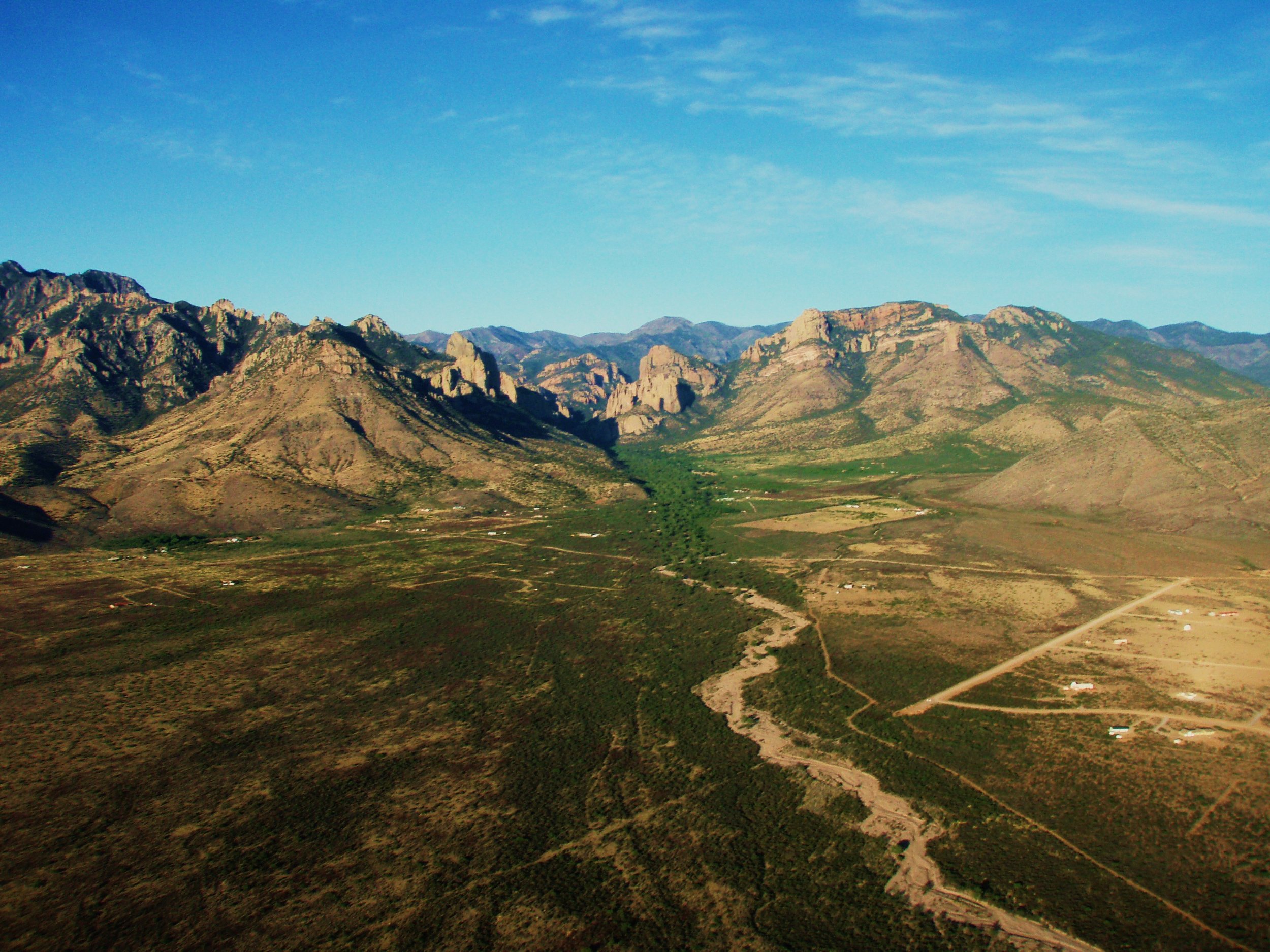
Aerial view of Portal, AZ and Cave Creek Canyon. Photo by BAlvarius/Wikimedia Commons
Straddling two states, the Portal/Rodeo community has a charm that affects arrivers who don't mind being in the middle of nowhere. But first, the confusing time zones takes getting used to. It isn't just that it is one hour earlier in Arizona and you may enter and leave both states multiple times in a day. It's that today we are slaves to smartphones and, when you leave the WiFi offered by the VIC or your lodging or wherever, your cell phone will pick up signal from New Mexico only. You may have remained in Arizona, but now your phone makes you think you've lost an hour. I've changed my setting to disable automatic time zones. The bigger issue with the New Mexico cell signal is in the event of an emergency. Should you need to call 911 you will be contacting services in New Mexico and may have to request transfer to Cochise County ARIZONA emergency dispatch. I have the direct numbers in my phone. Verizon is the only reliable carrier for use in the area, but the signal may be weak or nonexistent in some spots. One of the many services the Friends of Cave Creek Canyon provides at the VIC is public WiFi during open hours (9-4 daily, AZ time) and a Verizon Hotspot.

The VIC - Cave Creek Canyon Visitor Information Center
Nine miles into Arizona, Portal is the hub of the area. Although Rodeo, New Mexico has a post office and a small diner that has an extremely limited selection of groceries, arguably the only two major establishments are Rusty's RV Ranch and the Chiricahua Desert Museum. The latter is the must see attraction in the area. It sits between Rusty's to the north and the Rodeo proper to the south, directly where Highway 533 heads towards Portal and Cave Creek Canyon. After passing State Line Road you are in Arizona and Hwy. 533 is better known as Portal Road.

Chiricahua Desert Museum & Geronimo Event Center - Image from CDM Facebook
The Sky Island Grill & Grocery will soon become the third Rodeo establishment of note, but it is only just now sometimes opening its doors after being in development for years. It sits just inside New Mexico a short distance from the Chiricahua Desert Museum just before the bend to the northwest takes you into Arizona.
Consisting really of only one intersection, the crossroads of which is a complex known Portal Peak Lodge and Portal Store & Cafe, the tiny eclectic community of Portal, said to be home to more Ph.Ds per capita (retired) than anywhere else in Arizona, is centered on this venue for lodging, good food and, occasionally, live music. Up the hill to the north is the Portal Rescue & Fire where special events and meetings are also held and south down Rock House Road is the small post office and library. The rest of Portal are the residences that stretch out into the desert or up toward the canyon. I overheard one resident in the library mentioning how she feels like there are two communities - the desert and the canyon. This is where two worlds meet; the Chihuahuan Desert of Rodeo and eastern Portal and the foothills and entrance to Cave Creek Canyon, the Coronado National Forest and the Chiricahua Mountains.

Storefront - Lodge behind left - Image from web search
You may now be wondering about how many people live in the hamlet of Portal. A web search results in wide-ranging population estimates from 100 to more than 1300. Homes are secluded down dirt roads branching from Portal Road, but I can't imagine where one thousand or more people would reside. There aren't exactly apartment complexes. It is no surprise that the median age is just above my own soon-to-be 54, or that most households consist of just two people, generally a retired couple. It also isn't a surprise that more than 10% hold a graduate degree. What Portal residents have most in common is that many are birders and/or hikers and/or astronomers. And they live in one of the most beautiful places in America. They are also more than a little adventurous and industrious, and choose to live somewhere fairly remote. It is twenty-five miles each way to Animas, NM, where the Valley Mercantile offers hardware, feed, convenience groceries and, thankfully via 24-hour pumps, the closest fuel. About the same distance up a primitive mountain road and almost one hour's drive takes you to the interstate and San Simon, AZ where you can also buy fuel and one gas station offers a pretty good selection of produce, groceries and hardware. Most drive 75 miles northwest, entering New Mexico before returning to Arizona, to the Safeway in Willcox, AZ, or instead travel 60 miles or so southeast to the Wal-Mart in the border town of Douglas, AZ in order to shop. These cities also offer the closest health care services and other needs. Northeast of Portal-Rodeo, Lordsburg, NM is about the same distance as Douglas, but its little grocery store is pretty dismal. Some plan weekend trips 350 miles round-trip to Tucson to take care of many tasks every few months. It's the price you pay to dwell next door to a canyon and mountain range where Elegant Trogons and Blue-throated Hummingbirds fly, without the influx of city folk seen by Madera Canyon and other wonderful places.

Blue-throated Hummingbird, Cave Creek Canyon
Those, like me, who visit the Portal-Rodeo area and the northeast side of the Chiricahuas have a handful of choices for lodging. Here in Cave Creek Canyon, there are three forest service campgrounds and, beyond where the paved road ends and becomes a primitive road climbing the mountain, there are some excellent dispersed campsites. Those seeking cooler climes may wish to camp at Barfoot or Rustler Park, where the 8000 foot-plus elevation provides respite from the heat. However, like the other dispersed sites, there are no toilets. Those with RVs best stay at Rusty's; only one of the three USFS campsites can accommodate small campers and there are no hook-ups. Many birders choose one of several B&Bs along Portal Road or Portal Peak Lodge. The USFS also has two rental cabins on each side of the VIC. Housekeeping cottages at Cave Creek Ranch are one of the more popular places for birders to stay and it is within walking distance of the VIC. In fact, owner Reed Peters is also the president of Friends of Cave Creek Canyon, and it is at his Ranch that I receive mail, packages and do my laundry. Guests at Cave Creek Ranch enjoy coatis, javelinas, a large population of very tame Coues or Desert White-tailed Deer and a spectacular variety of birds.

One of the variety of cottages at Cave Creek Ranch - Image from CCR website
