#96 - Adventures with Others - Another Endemic Tarantula and More ...

I spend most of time alone by choice. It fits my personality. It is my preference. And it allows for maximum flexibility. I am guided by whimsy and most adventures are unplanned. I may in one moment alter my course or choose not only a new destination, but a different activity. Many of my hikes or drives, if not most, unfold naturally and often surprise me. My experiences are treasured alone in glorious solitude and then later shared here or via Instagram.

However, as I get ready to go to Tucson this weekend to pick up Joel and share this wonderful wilderness for a week, I am still savoring memories from a two day adventure with Dr. Brent Hendrixson and seven of his students from Millsaps College in Jackson, Mississippi. Brent has visited the American Southwest for a couple of decades and usually leads a summer field course that visits many amazing places. This year's course was Biogeography of the American Southwest and before they visited me his group had explored Arizona's Superstition and Catalina Mountains, Catalina State Park and the Grand Canyon. After they left here they headed to White Sands, National Monument, Carlsbad Caverns for the bat flight and Texas' Davis Mountains before driving home.

Cathedral Vista, Chiricahua Mountains. Photo by B.E. Hendrixson (second from left) with me looming behind a great group of students.

Cathedral Vista, Chiricahua Mountains. Photo by B.E. Hendrixson (second from left) with me looming behind a great group of students.

Last year Brent brought a different group here to the Chiricahuas for a single night and I had spent time with him and a few other students the month previous in both the Tucson and Phoenix areas. This year he had three nights planned for Cave Creek Canyon, but sadly they only stayed two. Still we made the most of the two days with adventures to the Peloncillo Mountains, Chiricahua Desert Museum and here within the Chiris.

While his crew set up camp at Sunny Flat Campground I joined them and met the seven students. Our plan was to head to the Peloncillos an hour and a half away to look for the endemic tarantula Aphonopelma peloncillo at its type locality. After spending over a week with eight people crammed in a van full of gear, the three girls were happy to be able to stretch out in my truck for the drive east into New Mexico and then south and southwest to the bootheel along the borders with Arizona and Mexico. Brent and the four guys piled back into their 12-passenger van that, as in years previous, was decorated with large tarantula magnets. The ladies were lovely and it was refreshing for this old loner to be surrounded by the vibrance and beauty of youth. Temperatures reached 109F in Animas where we turned south, but I had the A/C cranked and we listened to music from one of their iPhones.

Ninety minutes or so later, about thirty minutes after the paved road gave way to dirt and then rocky trail, we assembled in the chaparral-like oak woodland of the Peloncillo foothills. Last year I had searched the site we were visiting for the burrows of female tarantulas without success. I had found mature male Aphonopelma peloncillo while road-cruising for snakes, but had struck out when it came to locating burrows. That would change as the seven Millsaps students, their arachnologist leader and I dispersed and prowled the grassy area of the type locality (the precise location a species is described from). Having located the endemic A. chiricahua by pure chance (see #94), I was looking forward to finally finding a female A. peloncillo after last year's failures. It did not take long.

A_peloncillo_burrow_1366px_072318.jpg

Above is the silk-covered burrow of the first tarantula we located. This grassy field is grazed by open range cattle and among the cow piles and animal bones and ant mounds the students first found turreted holes belonging to wolf spiders or irregular openings belonging rodents. But within five minutes this distinctive silky entrance was discovered and Brent said to me, "You want the honors?" before explaining to his students that I had found and extracted tarantulas around the world. I used both flooding and tickling techniques and soon saw the gorgeous hairy legs of our prize.

A_peloncillo_burrow_legs_1366px_072318.jpg

The beginning of her tunnel angled sharply another direction rather than descending directly into the earth so when she would retreat even a short distance she would be lost from sight. I alternated between pouring water down the tunnel to move her towards me and then tickling for several series before I was able to get my tickling twig behind her and tap her forward and out into the light. 

Aphonopelma peloncillo, Peloncillo Mountains, Hidalgo Co., New Mexico

Aphonopelma peloncillo, Peloncillo Mountains, Hidalgo Co., New Mexico

Some rain drops began to fall, but our group continued to search the meadow. I returned to my truck to get a container for the tarantula as Brent wanted to take a couple specimens back to Mississippi. While I was away they located another burrow and I brought more water so that Brent could take his turn at extracting one of these beauties. The image below is the second female, photographed at my campsite the next morning on a flat piece of rock.

Aphonopelma_peloncillo_1366px_072318.jpg

As long as we were in the Peloncillos I also wanted to visit the type locality of the endemic scorpion, Diplocentrus peloncillensis. It is perhaps my favorite U.S. scorpion species and I had luck finding it each time I had tried last year. Rather than black-lighting at night as I usually do for scorpions (super effective, very easy work), I had always just flipped rocks at the site, which is on a north-facing slope that holds more moisture. The three mile or so drive up the mountain road (Geronimo Trail) between the tarantula and scorpion sites is a bit rough, and Brent didn't want to do it in the rental van. So I invited four of his students to climb into my truck and we headed up to a scorpion area atop a hill that is surrounded by a spectacular vista. I gave the team quick instructions and within minutes they had found a handful of scorpions.

Diplocentrus peloncillensis, Peloncillo Mountains, Hidalgo County, New Mexico near the Arizona state line and not far from the Mexico border.

Diplocentrus peloncillensis, Peloncillo Mountains, Hidalgo County, New Mexico near the Arizona state line and not far from the Mexico border.

My group walked down the road a bit to photograph the vista and then, as the dusk skies began to darken and a few more rain drops fell, we went to rejoin Brent and the other three. I hadn't driven far back down hill when I slammed on the brakes. Although small, the unmistakable shape of snakes leaps off of the roads for me, and I looked out my window at an eighteen-inch gorgeous olive serpent with a brightly colored belly. Everyone got out of the truck to hold our prize Ring-necked Snake.

Abby with our colorful friend

Abby with our colorful friend

Regal Ring-necked Snake (Diadophis punctatus)

Regal Ring-necked Snake (Diadophis punctatus)

When we got back to the tarantula site Brent told me that they had located and marked two more burrows and would leave them be if I wanted to record GPS coordinates. My friend Chad is visiting in three weeks and maybe I'll even take Joel down there to see one. Our plan was to wait for darkness a bit longer and then road-cruise our way back. Brent wanted to find at least one male and I was looking forward to showing his group a rattlesnake. Ten minutes or so after we began our drive back we came across our first - and only - male tarantula of the night on the road. The image below was captured the next morning at my corral.

Aphonopelma_peloncillo_male_1366px_072318.jpg

I was quite surprised that we didn't encounter more males, and for some time all I saw on the road was toads. We were driving faster than I normally road-cruise as the group didn't want to be up all night and I realized that I probably would miss any very small snakes. However, there was no way I would overlook a three-foot rattlesnake stretched out in the road, and I was soon excited to be able to show the students an adult Prairie Rattlesnake.

Crotalus_viridis_1366px_072318.jpg

The rest of the ride was uneventful; the roads oddly deserted by the live and dead snakes I usually observe. Even the jackrabbits and cottontails were scare, with mostly banner-tailed kangaroo rats and other rodents darting between pavement and shoulder grass. Back in the canyon I enjoyed a nightcap with the Millsaps crew, but they quickly disappeared into their tents leaving Brent and I to one last beer.

The next morning I spent a few hours doing my usual routine and then joined them at their campground at 9. One of the scheduled activities was to visit an area in Cave Creek Canyon past the Research Station where flipping rocks usually yields vinegaroons. Each student was required to give the rest of the group a presentation at various sites during their trip, and this day Abby, who is holding the Ring-necked Snake above, shared information about vinegaroons, not the least of which is their defense response releasing a chemical cocktail that includes a powerful concentration of acetic acid that gives these harmless “whipscorpions” their popular name. When Brent picked up the first one he purposely elicited a defense response so the students could smell the strong vinegar scent on his hands.

Brent shows a young vinegaroon (Mastigoproctus tohono) to the group while Richard takes profuse notes and O.C. ponders

Brent shows a young vinegaroon (Mastigoproctus tohono) to the group while Richard takes profuse notes and O.C. ponders

After a quick lunch back at their campsite, our next destination was the Chiricahua Desert Museum. I had spoke to owner Sheri Ashley in advance of the Millsaps visit and suggested that Brent contact her to arrange a tour. The amazing museum is equal parts reptile exhibit, snake breeding facility, desert garden, historical exhibit and gift shop/bookstore, and I knew the group would enjoy. But my expectations were exceeded when Rachel, one of the reptile keepers, took us to the off-exhibit buildings to view their behind-the-scenes reptile breeding operation. Some students had never held a snake and were apprehensive at first, but it was wonderful to see Marlee hold snakes as below.

Marlee with a Mexican Pine Snake

Marlee with a Mexican Pine Snake

When we eventually made it back to Sunny Flat Campground everyone was looking forward to relaxing in their hammocks. Brent and I sat sipping a beer and before long were quizzing the students about the biogeography of the Sky Islands including the Chiricahuas. Arachnologist became mixologist as Brent made me a couple of refreshing mint juleps to go with my Dos Equis ambers. We had a relaxing rest of the afternoon, but another thrill was about to come. 

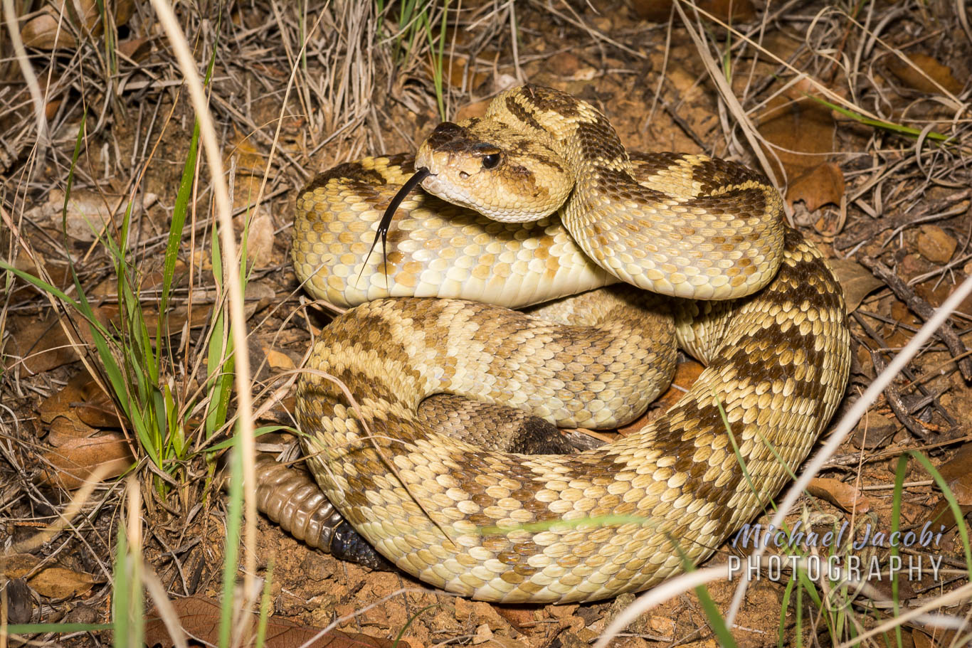
We wanted to visit Cathedral Vista closer to dusk for group photos including the one that kicked off this blog, and walked down the road, made the short hike out to the viewpoint and then returned. Walking back a family with a young boy on a training wheels equipped bicycle headed towards us and said a snake had just crossed in front of them. Sunny Flat is a popular place for my favorite rattlesnake, the Western Black-tailed, and they seemed to know that was exactly what it was. We searched the bushes and grass where it was said to have gone to no avail, and Brent and I returned to the campsite. But one of his students, Liam, had continued to poke around the area and I heard him calling. I shouted back and forth and learned that the rattlesnake was right there in front of him so I grabbed one of my snake hooks and my camera and rushed back over to him. Sure enough, a gorgeous black-tail a bit over three feet long was at the grassy edge and I grabbed it. 

Brent hadn’t joined us yet and as he started our direction I had already told the family, who was now watching and Liam had told that I do this all the time so don’t worry, that I would relocate the snake so it wasn’t by their campsite. Two days earlier someone had reported a black-tail at the same exact campsite so I decided it might be time for me to move the beauty somewhere less frequented by kids on bicycles. I shouted to Brent to return to my truck and grab my big storage tub so I could contain it. He brought it over and then I had Liam hand him my camera so he could take the image below.

Me and a Western Black-tailed Rattlesnake (Crotalus molossus)

Me and a Western Black-tailed Rattlesnake (Crotalus molossus)

The following portrait of the snake was taken when I released it, coincidentally near the vinegaroon site from earlier that day. I excused myself from the group long enough to drive up canyon, release and photograph the snake, and then make a quick pit-stop to my Wheelhouse for some dinner. When I rejoined them later the group had set up a sheet and lamp to attract moths (and jewel scarab beetles that sadly didn’t come) and the students got to see sphinx moths and hawk moths and a myriad multitude of smaller moths and beetles. We hung out for a couple more hours before I bid them goodnight. The next day I had to man the Visitor Center and, after stopping to say goodbye, they pushed on to the final five days of their adventure.

Crotalus molossus

Crotalus molossus

#95 - Monsoons & Mountain Trails

The trail to Silver Peak is four and a half miles. With its trailhead just up the road from my campsite, and beginning with an ascent of a ridge just behind my corral, the Silver Peak Trail #280 has an elevation gain of three thousand feet. It is a true test of endurance. Many locals hike the "first mile to the first gate" as exercise. Despite the thousands of feet of vertical ascent ahead, this switchback-free stretch is one of the toughest along the trail, states the trail description.

Even though I can shortcut the trailhead and climb the hill behind the corral to access the trail, I waited until this morning to visit it for the first time of the year. I did not heed the forecast. Two days ago monsoon season officially kicked off with localized thunderstorms that brought close to an inch of rain to Portal, Arizona just outside the mountains, but curiously barely registered on the Southwestern Research Station (SWRS) weather monitor three miles up canyon from me.

The North American monsoon generally affects the area from the second week of July until as late as mid-September. It is also known by locally biased names like "Arizona Monsoon, New Mexico Monsoon, and Southwest Monsoon", but North American is most appropriate as the pronounced increase in thunderstorms and rainfall is seen over much of the southwestern United States and northwestern Mexico and is geographically centered over Mexico's Sierra Madre Occidental range. Wind patterns reverse in summer as the land that has been intensely heated by the sun (thermal low pressure) causes the prevailing winds to start to flow (high pressure) from moist oceanic areas to the arid landscape. Monsoon season begins as early as late May in Mexico and arrives in Arizona and New Mexico as summer begins and June gives way to July. As temperature cools in September and drier conditions prevail, the monsoons lose their energy.

This year has been particularly dry in southeastern Arizona. Locals tell me how there was "no winter". Snow and rain were scarce. The SWRS reported one day with 0.13" precipitation in January. One significant day of rain in February brought that monthly total to just under two inches. March had one day of rainfall (0.47"), and April and May were completely dry. When a fluke rainstorm fell for two days in mid-June it was a gift from the skies, but it was due to a tropical storm off the Gulf of Mexico and didn't herald the beginning of our rainy season. But when less than a quarter inch fell on June 29 at SWRS, but closer to an inch was seen in Portal, residents rejoiced. The monsoons wouldn't truly begin for another ten days or so, but the ocotillo greened and then bloomed, the grass at the VIC grew a bit greener and baby lizards emerged.

The Fingers can be partially seen at right

The Fingers can be partially seen at right

As I passed the first 'pedestrian gate' on Silver Peak Trail this morning, I was posting scenic snapshots and videos to my Instagram story. I then looked up at The Fingers, a rocky hand reaching to the sky from the peaks, and saw the storm that was about to envelop me. I posted both my apprehension to continue on and that caution wasn't my style, and then had only moments to find a large boulder formation to protect my camera in before I was soaked and scurrying down trail to find any tree that would offer cover. Torrential rain fell and thunder boomed as lightning cracked. It would be more than an hour before I crawled out from under that pinyon pine and I was saturated. I looked back up at The Fingers and saw a waterfall had formed on an adjacent steep cliff. I had been upset with myself for not carrying my large camera bag, which as a rainfly, or at least not having a trash bag in my small knapsack to protect my camera and lens. I retrieved the lens from beneath the boulder overhang and started down the trail, but the rain started again. Once again, I huddled beneath the mediocre cover of a scraggly desert pine and this time tried to make room in my pack for the camera. It wasn't until I got back to camp that I realized that I am a bonehead and my Lowe camera knapsack actually does have a rainfly. Not that it would have mattered. When the storm's darkness came over the mountain and down the trail I had no choice but to become drenched squatting anywhere I could.


But let's go back almost two weeks to the last day of June and a different, and much drier, mountain trail. It was a day I will always remember. The Trans-mountain Road, or Forest Road 42, climbs Cave Creek Canyon up the mountain to Onion Saddle, where you can crest the northern Chiricahuas and descend Pinery (Pine) Canyon to Chiricahua National Monument or choose to drive south toward Rustler and Barfoot Parks. Onion Saddle is about a dozen miles up the mountain from Cave Creek Canyon, much of it on winding, primitive road with numerous single-lane switchbacks. The pavement ends just three miles up canyon from the Visitor Center, passes SWRS three-quarters of a mile later, and then the primitive road ascends from 5400 feet to 7600 feet at Onion Saddle. There you either drop down the mountain towards the Monument and paved roads north to Willcox, or continue to climb to Rustler Park (8500 ft) and Barfoot Park (8200 ft), where a network of trails centered around the Crest Trail (#270) runs along the peaks (hence, "crest") to the apogee at Chiricahua Peak (9700 ft). During the Horseshoe 2 Fire of 2011, much of this montane area burned and the landscape and associated trails continue to recover. Volunteer trail crews hike with chainsaws to part trees that continue to fall over the many paths that explore this alpine region.

With the monsoons yet to arrive, June is the hottest month of the year. The temperature can be as much as fifteen degrees (Fahrenheit) cooler at Barfoot and Rustler than down in Cave Creek Canyon, which itself is often as much as ten degrees cooler than the desert just outside the mountains. Barfoot and Rustler Parks are set in mixed conifer forest and the landscape is more Rocky Mountains than Sonoran or Chihuahuan Desert. Adding to the allure, they are home to montane wildlife like Steller's Jays, Mexican Chickadees, Cliff Chipmunks and, for me sexiest of all, the small, mountain rattlesnake - the Twin-spotted. Although the Trans-mountain Road is steep and rugged, with amazing vistas mixed with scary, sheer drop-offs along its single vehicle width, I ascend it as often as I can to reach cooler climes and gorgeous surroundings.

Yellow-eyed_Junco.jpg

My long-time readers will remember stories about this diminutive rattlesnake from last year's blog entry on searching the expansive high elevation talus slopes that form its habitat. Those with keen memories will also recall that I had quite the tumble on the sharp rock causing blood loss to my legs and body fracture to my ring flash. This year I have confined my exploration to the base of the rock slides and adjacent wooded areas and meadows. But discussing trails with both visitors and locals had me intrigued to explore the high altitude trails of the region.

I had tried to access Barfoot a couple of days earlier, but as I drove from Barfoot Junction where you head left toward Rustler or right for Barfoot I crossed the cattle guard and was stopped by several real-life cowboys ranging cattle. It was a curious sight above 8000 ft. and I couldn't recall seeing any cattle this high before. But, there I sat, perplexed, watching a half dozen dogs circling four head of cattle lined up on the road with three or more people in Stetsons, boots and demin on horseback directing the dance. After I sat there some time, one horseman came my way and I soon realized that it was a boy no more than 14. I swear he even had tobacco in his mouth when he tipped his hat to me. Pulling his horse up beside my truck, he told me that it would be awhile. He said if he let the cattle break free they might not be able to round them up again. No worries, I told him, and I backed down the road and eventually moved on to Rustler to photograph the elusive and nervous Cliff Chipmunk.

Cliff_Chipmunk.jpg

But the trail that continued to interest me was Barfoot Lookout Trail. Although I knew that the fire lookout cabin that was built in 1935 by the Civilian Conservation Corps no longer exists, after being burned during the 2011 Horseshoe 2 Fire, the summit of Buena Vista Peak (8800 ft) now has a little stone-walled viewing area and offers a breathtaking panorama of the surrounding mountains overlooking prime rattlesnake habitat. There also is a solar panel station and radio repeater and the foundation of the old cabin and outhouse may be seen.

IMG_1722.JPG

Although the Crest Trail itself intersects the Barfoot Lookout Trail, I would be starting at the lower terminus near Barfoot Meadow. It begins to climb adjacent to Barfoot Spring and after passing through a stand of burned timber reaches a thicket of quaking aspen saplings. Eventually the trail bends sharply to the left and the last three or four hundred yards climbs the mountainside without any switchbacks. Once you reach Barfoot Saddle you are at the Crest Trail junction where I chose to make the climb to Buena Vista Peak.

Along the way I would see more Yellow-eyed Juncos, a bird that thrives at the mountain tops, baby Yarrow's Mountain Spiny Lizards and, during my initial descent, Broad-tailed Hummingbirds feeding at the Bearlip Penstemon flowers abundant on the mountain slope.

The road up to Barfoot (FR 357) looking down east from the "lookout"

The road up to Barfoot (FR 357) looking down east from the "lookout"

Looking west down on whence I came ...

Looking west down on whence I came ...

IMG_1091.JPG

Just enjoying the trail, reaching the summit, and meditating on the spectacular vistas would have made for a wonderful Saturday. But the best was still to come. At some undisclosed point during my descent, I would stumble upon what I consider the jewel of the mountains - The Twin-spotted Rattlesnake. This protected species is a denizen of talus slopes and rock slides, but is known to be found away from much rock in the vicinity of rotting wood and other forest cover beneath the conifers. A streak of silver flashed upon the trail. I leaped forward, almost stumbling over a log or two. I am sure comedy ensued, but not even a bear was present to witness my grace. Disappearing beneath a rock on the other side of the trail, the cooperative snake gave me time to toss off backpack, camera, binoculars, hat and probably even my glasses as I tried to switch from long bird lens to macro setup in seconds. I didn't have an external flash so the lowly built-in speedlight would have to suffice. I think I may have had enough time to chug some water and wipe my brow before I kneeled beside the rock and tried to catch my breath. I had had only a momentary glimpse, but there was no mistaking that this must be a Twin-spotted Rattlesnake. The species only rarely reaches two feet in length, and this snake was every bit of it, maybe more. Nothing else was silver-grey and little else lives at 8500 feet elevation. As a protected species, it is unlawful to pursue, harass, etc. and certainly restrain or collect, so I wanted to disturb as little as possible as technically even flipping the rock would be pursuing. But flip I did, and beneath was an adult Twin-spot as big as they come and suprisingly cooperative. I wished I could pose it on rock for a better photographic setting, but I snapped a few images and then videotaped it with my iPhone as it slithered into the forest.

Crotalus_pricei_graphic_1366px.jpg
The Twin-spotted Rattlesnake (Crotalus pricei) is the smallest American rattlesnake and occurs at the highest altitude. It is a protected species found in the United States only in Arizona’s Chiricahua, Huachuca, Santa Rita and Pinaleno Mountains. Our western subspecies ranges south into Mexico (Sierra Madre Occidental) with an isolated subspecies being found in northeastern Mexico (Sierra Madre Oriental). Diminutive and slender, it is a silver, blue-grey or greyish-brown rattlesnake that only rarely reaches two feet in length. Its head is not as broad as that of most rattlesnakes, and with paired dorsal blotches that give it its name, limited range, specific habitat, and orange color of the newest rattle segments, it cannot be confused with any other snake. The Twin-spotted Rattlesnake is primarily known from Petran Montane Conifer Forest at elevations of 7500-9000 feet where it is generally an inhabitant of expansive talus slopes and rocky outcrops, but this photo depicts an example of a snake found in adjacent alpine forest among rotting logs and rocks. I encountered this very large adult along a trail at 8500’ while descending from one of Chiricahua’s peaks. The Twin-spotted Rattlesnake is active during the daytime and primarily feeds on the Mountain Spiny Lizard (Sceloporus jarrovii). Its young are born in summer when baby lizards are abundant in its rocky home. July and August is also the time when breeding takes place. Like other montane rattlesnakes, it delays fertilization of its ova and development takes place very slowly, resulting in birth of a handful of small live young the following summer.
— Michael Jacobi, for Friends of Cave Creek Canyon Newsletter

In closing, finally, I'd like to apologize for not posting for three weeks and make you aware of a Chiricahua Mountain Wildlife slideshow video I have published to my YouTube Channel. It is a compilation of many of my wildlife images captured from April through June 2018. Please enjoy. Cheers, MJ

#86 - Up or Down? Live from the Swim Spa ...

Herpers look down. We cruise roads in darkness or twilight with our eyes scanning and darting, hypersensitive to serpentine shadows and slinky shapes. We hike trails with our heads on swivels, surveying the landscape and fixing our gaze on likely crevices, protective tree bases and favorable basking spots. Hunting tarantulas is much of the same. Especially when you're a herper. My early years of seeking tarantulas were all in the desert. We have no tree-dwelling American species. Even in the rainforest, with my field trip mates looking for pink-toed tarantulas in Suriname or ornamental 'tiger spiders' in Sri Lanka, I battled my conditioning to look down.

Birders look up. It's much harder on the neck, which is why all of their binocs - or 'bins' as birders like to say - are on elastic harnesses distributing the weight to the back and holding the bins to the chest. My neck is sore. After countless hours of holding my head back as I look for flittering flashes of color in Arizona cypress and sycamore, Alligator juniper, Apache pine and silverleaf oak.  I am a 'budding birder', which is a term applied to me by a Cave Creek Canyon Visitor Information Center [VIC] volunteer colleague not my own words. Yeah, I'm learning trees too. They tend to make you look up as well. The neck strain is real.

And here I am soaking my aches. Blogging from the rejuvenating water of Rusty's swim spa. You can set it to produce current that allows you to swim 'laps' treadmill style. That's too much like work. There also is the jacuzzi setting. With the water set to 93ºF and the outside air currently a couple of degrees above that, it a 'mildly hot tub' and soothes my birding neck and my twisted back. My volunteer work at the VIC has included some landscaping duties and today I tried to compact the path to our restrooms and the center itself by wrestling a ditch tamper to no avail.

But back to the budding, nay ASPIRING, birder ... One of our VIC staff couples, Laura and Steve, who are very avid and accomplished birders mingle with the flocks of bin-clutching aviphiles (or do you say ornithophile?) along South Fork Road and South Fork Trail, which I probably have mentioned is in the top 5 places to bird in America, and engage them in discussions and do anything they can to enhance their Cave Creek Canyon birding experience. It's what we do everyday at the VIC as we talk about what has been seen where and detail hotspots throughout the San Simon Valley and Chiricahua Mountains, but it's more fun when you can say 'hey, did you see that Painted Redstart carrying nesting material to the base of that tree (whether you know what tree it is or not!)?' and 'they're ground nesters, you know'. So I have been meeting Laura and Steve each Saturday morning and learning the species, quickly compiling lists of 30 or 40 or more seen before lunch. Laura is an 'ear birder' and identified each by song while Steve searches for the bird where the sound came from. This past Saturday they were joined by a woman for some time and slowed down a bit so I decided to move up trail alone listening for the song of the Elegant Trogon. This distinctive sound (click here) is like nothing else and reverberates in the canyon. Most birders visiting the trail are seeking this bird above all and many have traveled thousands and thousands of miles just for the chance to see one. I hiked up South Fork Trail, which follows Cave Creek and crosses it back and forth numerous times. At this time of the year, between the melt of winter's mountain snow and the monsoons that will begin at the end of June, the first two creek crossings are dry and the third has shallow water easily transversed by rock-stepping. Just above the third crossing I heard a male Trogon and quickened my pace up canyon. After the fourth creek crossing there is a pool of water known as the 'Bathtub' and here the dramatic barking of his song was just above me.

The Bathtub, South Fork Trail, Cave Creek Canyon, Chiricahua Mountains, Arizona

The Bathtub, South Fork Trail, Cave Creek Canyon, Chiricahua Mountains, Arizona

The possibility of seeing an Elegant Trogon has undoubtedly drawn more birders to southern Arizona than anything else that flies. Whether it is here in the Chiricahua Mountains or in the Santa Ritas south of Tucson, this gorgeous - some might say gaudy - bird comes north from Mexico to breed in wooded canyons such as along the South Fork Trail of Cave Creek where it favors sycamores that offer nesting sites created by not one, but two, species of woodpecker. The Trogon is dazzling in its metallic brilliance of green, red and copper. It has a large head, stocky build and long square-tipped tail, and is fairly 'sluggish', often perching in one spot for an extended period only to fly in short bursts to neighboring trees where it rests once again. Birders who are fortunate to have an encounter can often sit on a large rock, rehydrate or have a quick picnic and watch a stunning male for quite some time while listening to its distinctive croaking song.

After pausing at the Bathtub and not hearing the male's song for five minutes or so, I heard it just further up canyon. With the massive rhyolite rock faces of the Chiricahuas reflecting sound, the Trogon's loud croak or bark can be misleading. Many birders comment on how it can sound farther away than the bird is, and also how a song heard farther up trail can disappear only to come from behind you. They sing and then they don't and the silence can be due to relocation, especially as they now compete for the arriving females. I headed up creek to the fifth crossing and his call was right upon me. With my head tilted back scanning the trees it took me a moment to notice the tell-tale presence of other birders. There sitting upon large flat boulders in the creek with their bins glued to their eyes and necks strained rearward were three birders and it only takes observing the direction of their optics to locate their prize. I joined them for what was perhaps fifteen minutes and then after they headed back down the trail I stayed for an hour. I pointed the majestic male out to some other passerbys and stayed until a family group with small children ruined the party. They were ignorant of the bird of a lifetime above and when I asked they keep it down and pointed out both the unusual song and the amazingly colorful bird I got only a disinterested 'pretty bird'. This male didn't perch in an optimal location for the reach of my 400 mm lens, but I'll share here the two best images I was able to capture.

Trogon elegans, South Fork Trail, Cave Creek Canyon, Chiricahua Mountains, Arizona

Trogon elegans, South Fork Trail, Cave Creek Canyon, Chiricahua Mountains, Arizona

Trogon elegans, South Fork Trail, Cave Creek Canyon, Chiricahua Mountains, Arizona

Trogon elegans, South Fork Trail, Cave Creek Canyon, Chiricahua Mountains, Arizona

I returned in the past few days and had encounters with two males and also got to see a Blue-fronted Hummingbird on a nest. I look up. I look down. I'm an equal opportunity naturalist these days, I suppose. This morning I am off to look for Burrowing Owls in a location another VIC colleague shared with me. I'll leave you now with an image of a Scaled Quail taken right here at camp. They run on the ground for the most part so they allow you to look up or down.

Scaled Quail, Rusty's RV Ranch, Rodeo, Hidalgo County, New Mexico

Scaled Quail, Rusty's RV Ranch, Rodeo, Hidalgo County, New Mexico